
Cairns is a paradise for nature lovers and outdoor enthusiasts, offering a range of walking tracks and trails that showcase the stunning natural beauty of the region. Whether you're looking for a leisurely stroll or a challenging hike, Cairns has something for everyone. Here are just a few of the many walking trails and tracks available in Cairns. Remember to wear appropriate footwear, bring plenty of water, and be mindful of your surroundings when exploring the trails.
Mt Whitfield Conservation Park is an island of rainforest only ten minutes from the Cairns central business district and surrounded by suburban homes. Although not part of the World Heritage Area, Mt Whitfield provides an easy introduction to the tropical rainforest environment and contains two walks.
The Mt Whitfield Arrow paths are well maintained and easily accessible. You will pass through a range of rainforest vegetation, Brush turkeys and other birds are easily heard and observed. Throughout the walk there are interpretive signs about the plants and animals. There are also numbered markers indicate places of cultural and historical significance.
For the adventurous, the 5.4 kilometre Blue Arrow track loops through the Mt. Whitfield Conservation Park. This is a long walk with rough track. Plan to head off early as the heat in North Queensland is extreme especially in Summer, Nov-Feb.
This walk is a continuation of the Red Arrow walk and branches off near the top of the hill. This 2-3 hour walk can be rough and steep in places and is recommended only for fit hikers. You should carry water and wear strong shoes.
Mt Whitfield and Mt Lumley are over 300 metres above sea level and offer spectacular lookouts over Cairns and surrounding areas.
Red Arrow Walk
Distance 1.5 km
Time: 1 hour (return)
Grade: Moderate | Steep hills with steps
The 1.5 kilometre Red Arrow track takes about 40 minutes and includes a series of steep steps which meander through the forest to the top of a rise with excellent views of Cairns City & Coral sea. The Red Arrow entrance is located just past the tanks, about a kilometre along.
Begin the walk from either the trail head near the Botanic Gardens Visitor Centre or to the east of the Tanks Art Centre. After about 300m from either starting point, the tracks come together at a large stand of bamboo.
From this point the track becomes a circuit. The right branch passes through an arch of the towering fishpole bamboo. Past the bamboo, the track continues uphill through open woodland to two lookouts, providing great views of the city, the coast and the busy Cairns airport.
The left branch of the circuit passes through a shady rainforest gully.
Blue Arrow Walk
Distance 6 km
Time: 4 hours (return)
Grade: Moderate | Steep hills with steps
The Blue Arrow walk climbs to over 300m altitude on a track that is sometimes steep and narrow and requires a moderate level of fitness. Walkers should allow plenty of time to complete the walk before it gets dark—do not start after 2:00pm.
The Blue Arrow circuit starts about half way around the Red Arrow circuit. The track begins with a steep 600m climb to a lookout with views of the coast north of Cairns and a glimpse of Lumley Hill. A short distance beyond the lookout the track divides into a circuit, which can be walked in either direction. The right branch passes through rainforest and open grassland before climbing steeply towards Lumley Hill. The left branch climbs through rainforest on stairs created by the roots of rainforest trees.
Yellow Arrow Walk
Distance 2.3 km
Time: 2 hours (return)
Grade: Easy | Steep in places
The Yellow Arrow is a walking track of 2.34km in length which will take visitors about an hour to complete. Incorporating key viewing points over Cairns and Aeroglen, the trail showcases natural features including large rock slabs and boulders, rock lined gullies and large native trees. This track provides a circuit route via the Red Arrow, Collins Avenue and Saltwater Creek back to Aeroglen.
Green Arrow Walk
Distance 3 km
Time: 3 hours (return)
Grade: Moderate | Steep hills with steps
The Green Arrow is a 3km track which starts near the top of the Blue Arrow loop and branches off to the west ending at Whitfield. It offers views along the coast to the north of Cairns, as well as tropical greenery to shade visitors as they walk along the paths. Steep hills and stairs provide a challenge for those who take on this track, which will take about three hours to complete. The track can be accessed by walkers from Whitfield, in Bel Air Drive.
This track will take visitors past rainforest trees and mangroves, and will take about half an hour to an hour for moderate walkers to complete. The western end of the Centenary Lakes boardwalk is located across from the main entrance to the Flecker Botanic Gardens, while the eastern end is adjacent to the Saltwater Creek footbridge. Keep an eye out for native birdlife including the lovely fairywren, which inhabit this area.
Initially a sugar cane farm and sand mining quarry, Cattana Wetlands has been converted into a conservation park lush with tropical wildlife. A 420m boardwalk will take visitors through rainforests and palm forestry. This low-key walk is suitable for parents with prams or young kids on bikes.
With a distance of about one kilometre to the top, this track takes about half an hour to climb. There are steep spots and steps to add a physical challenge for walkers. The entrance to the Earl Hill Summit Track is off Roberts Road in the Bluewaters Estate near Trinity Park. Parking is available along the roadside or at the Bluewater Marina. Dog-walkers are welcome here.
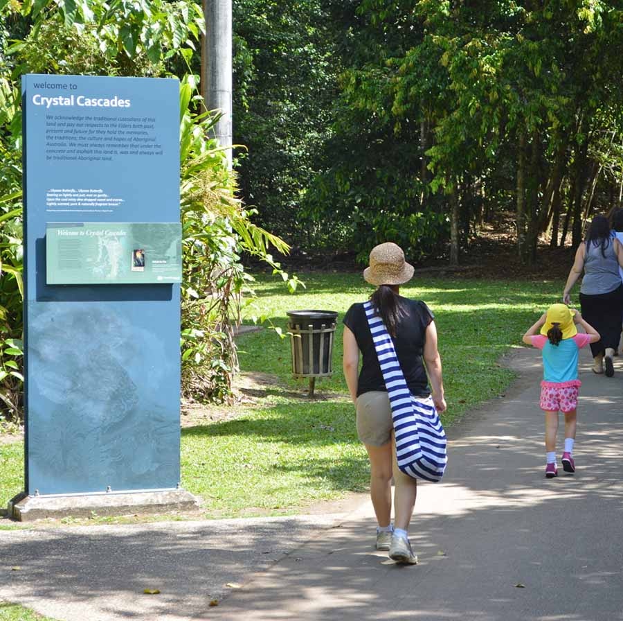
The track to Lake Morris is located on the path to Crystal Cascades. Mobile reception is poor once you are on the track, so make sure someone knows where you are. Give yourself around 3 hours minimum for the return trip. And take plenty of water!
The walk to Lake Morris starts just next to the picnic area & toilet block at Crystal Cascades, about 150 metres along the path from the car park.
The scenic path to Crystal Cascades is easy going and has many small waterfalls and a wonderful rainforest environment.
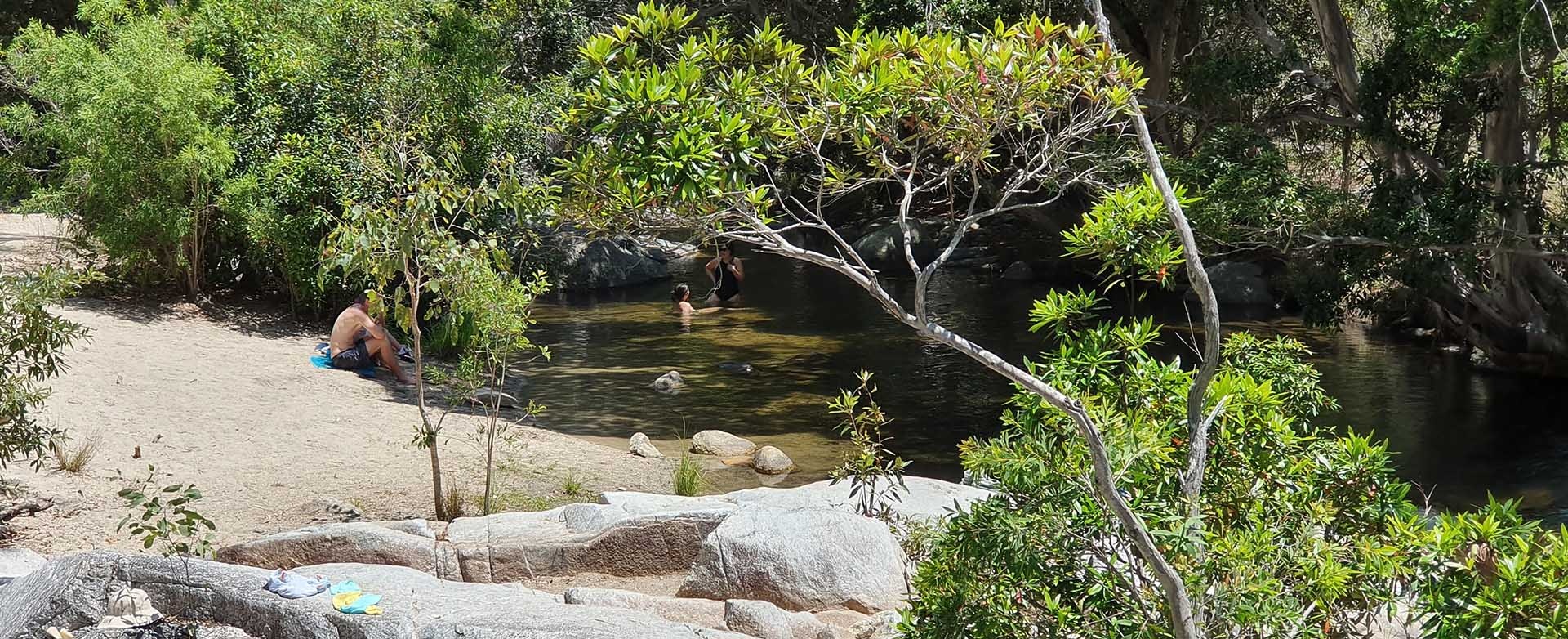
I recommend jumping in for a swim after you tackle the Lake Morris trail. There are many spots to choose from along the path.
The Crystal Cascades waterfall is located at the end of the path. Beyond this point are the water intake pipes, so no swimming is allowed past here.
Some say 45 minutes to the top, but we beg to differ. This track is definitely not moderate. The first half hour is quite steep and then it tapers off. Make sure you have shoes with good grip.
Once you have reached the timber power-pole, there is a nice view over brinsmead valley and towards Yorkeys Knob. From here on the track widens (for vehicle access) and is less steep.
When you reach the yellow gate turn right and walk along Lake Morris Road towards the lake and lakeside Cafe.
Just before you reach Lake Morris there is a sign with a map of the area.
After the walk, I wanted to order everything on the menu. Coffee & Sandwiches were great!
Enjoy the serene views over Lake Morris before some well-earned lunch.
The less strenuous trek down the hill is a good chance to take in some of the surrounding rainforest environment.
